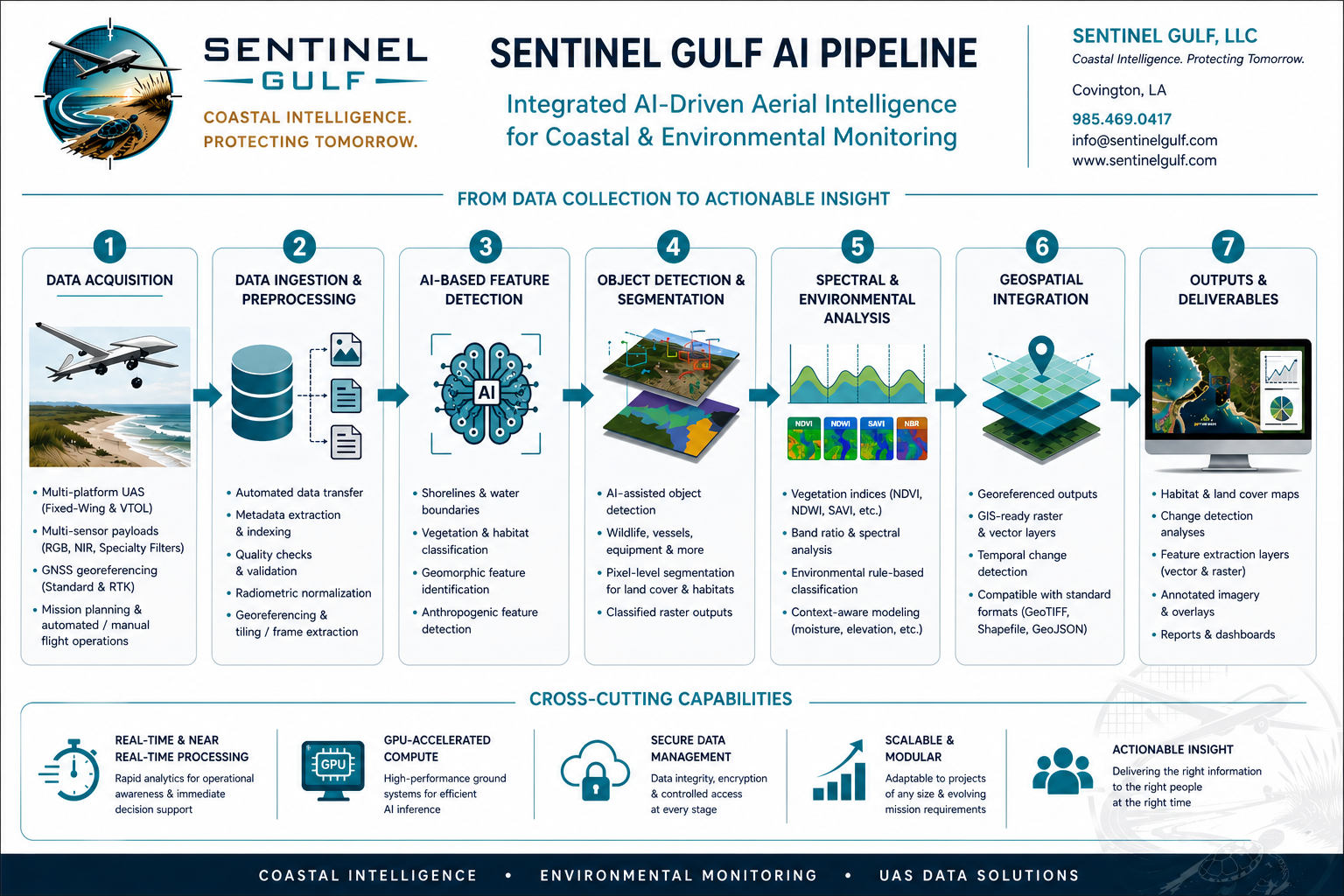
Coastal aerial intelligence for real-world environmental decisions.

Built for Dynamic Coastlines

Sentinel Gulf delivers aerial data collection, AI-assisted analysis, independent construction verification, and geospatial intelligence for coastal engineering, environmental monitoring, restoration, and disaster response operations.

Sentinel Gulf logo
SERVICES

From field collection to coastal intelligence.

Sentinel Gulf supports coastal, environmental, engineering, construction QA/QC, and response missions with aerial data collection and deliverables designed for real operational decisions.

Coastal Monitoring

Shoreline mapping, erosion monitoring, barrier island assessments, post-storm documentation, and recurring coastal condition surveys.

Habitat Intelligence

Remote sensing-based imagery indices and analytics, habitat delineation, restoration monitoring, vegetation condition review, and GIS-ready mapping outputs.

Wildlife Monitoring

Wildlife detection support, nesting-area documentation, disturbance mapping, and aerial survey workflows designed to reduce field time and improve coverage.

Disaster Response

Rapid situational awareness, storm damage assessment, debris mapping, access documentation, and repeatable post-event survey products.

Engineering Support

Orthomosaics, GIS deliverables, CAD-based deliverables, construction progress documentation, base mapping, and project visualization support.

Construction QA/QC

Independent RTK-controlled LiDAR surface collection, contractor transect comparison, progress documentation, and pay-quantity verification support.

Data Products

GeoTIFFs, GIS layers, annotated imagery, map exhibits, summary reports, and client-ready deliverable packages.

CONSTRUCTION QA/QC

Independent surface verification for fill-pay construction.

Sentinel Gulf helps engineering firms and construction managers verify contractor-submitted quantities using independent RTK-controlled LiDAR surfaces, contractor-transect comparison, and defensible volume reporting.

Independent Dense Surfaces

Sentinel collects dense RTK-controlled LiDAR data across fill areas, restoration sites, beaches, levees, marsh platforms, and other active construction surfaces.

Contractor Line Comparison

Contractor-submitted transects can be compared against Sentinel-derived surfaces to identify where sparse line data agrees with or differs from the actual constructed condition.

Volume Verification

Sentinel can provide both traditional average end area volume summaries and LiDAR surface-derived volume comparisons for pay-request QA/QC review.

Pay quantities should be based on defensible field evidence. Sentinel provides an independent verification layer that helps engineering firms review contractor submissions before presenting pay requests to project owners.

TECHNOLOGY

From Data Collection to Actionable Intelligence

Sentinel Gulf combines advanced aerial platforms, RTK-controlled field collection, LiDAR-enabled surface verification, AI-assisted analytics, remote sensing workflows, and geospatial integration to transform raw data into defensible intelligence products. Our technology pipeline enables faster decision-making for coastal engineers, environmental teams, restoration stakeholders, and emergency response operations.

Sentinel Gulf AI pipeline overview
FLEET

Operational Fleet

Two aircraft classes support different mission profiles: one optimized for rapid deployment and one built for premium long-endurance sensing operations.

Sentinel Manta aircraft RAPID RESPONSE

Sentinel Manta

Built to deploy fast, fly low, and get useful answers when conditions are changing quickly.

Sentinel Manta is a long-range VTOL/pusher platform optimized for rapid deployment in dynamic coastal environments. Designed for flexible field operations, Manta supports high-resolution video feeds, RGB/NIR multispectral imaging, quick-look survey operations, and long-range communications.

Sentinel Manta combines rapid deployment, flexible sensing, and operational mobility in a platform designed for real-world coastal response missions.

When access is limited, timelines are compressed, or conditions are changing by the hour, Sentinel Manta is built to get airborne quickly and start delivering intelligence immediately.

  • VTOL/pusher configuration
  • Rapid deployment from constrained sites
  • RGB/NIR multispectral camera stack
  • High-resolution video feed
Sentinel Overwatch aircraft PREMIUM ANALYTICS

Sentinel Overwatch

The kind of aircraft that makes people stop and ask what just flew overhead.

Just think...you’re sitting on your front porch when you see something huge overhead. You look up, hear almost nothing, and ask yourself: What is that thing?

Sentinel Overwatch is a long-range, high-endurance pusher-type platform built for advanced environmental intelligence missions. Designed to fly farther, stay longer, and operate quieter than traditional systems, Overwatch delivers the sensing power and persistence real missions demand.

Sentinel Overwatch combines persistence, range, and unusually quiet flight in a platform built for real-world coastal intelligence missions.

  • Long-range/high-endurance flight profile
  • Interchangeable premium sensor packages
  • Advanced environmental analytics support
  • Long-range communications
CLIENTS

Who We Serve

Sentinel Gulf is built for organizations that need reliable aerial intelligence, defensible mapping products, and fast operational insight along dynamic coastal systems.

Coastal Engineering Firms Environmental Consultants Government Agencies Restoration Contractors Construction Managers Wildlife Programs Disaster Response Teams
ABOUT

Who We Are

Sentinel Gulf was built at the intersection of coastal science, geospatial analytics, and operational aviation.

Founded by an environmental scientist and GIS practitioner with over 20 years of experience, Sentinel Gulf is a disabled veteran-owned small business based on the U.S. Gulf Coast, built to deliver faster, smarter, and more actionable environmental intelligence for dynamic coastal environments.

We understand the operational realities of working in complex coastal systems because we live and work here. Our mission is simple: provide agencies, engineering firms, environmental teams, and restoration stakeholders with reliable, defensible aerial intelligence that supports better decisions in the field.

CONTACT

Contact Us

Have a coastal monitoring, construction QA/QC, habitat mapping, wildlife survey, or disaster response mission to scope? Sentinel Gulf starts with defined deliverables, clear assumptions, and a practical path to useful data.

Covington, Louisiana | U.S. Gulf Coast Operations
info@sentinelgulf.com